The field of action in Spain of the EGTC Duero-Douro takes up a surface more 5000 km2 and includes 93 local entities located in the provinces of Zamora (Sanabria/Carballeda, Aliste/Alba, Los Arribes/Sayago, Campos/Pan Regions) and Salamanca (Ledesma, Vitigudino, La Fuente de San Esteban, and Ciudad Rodrigo) in the Spanish side. Besides is a territory whose link is the Duero River). Therefore, it encompasses the border field of Castilla y León, from the Sistema Central as the limit to the South until the Sierra de la Culebra to the North.
TERRITORIA.NET will be developed in all local entities members of the EGTC Duero-Douro on the Spanish side, since, as well as, be part of this EGTC, have common needs that have to be tackled together. Specifically:
Alcañices, Almaraz de Duero, Bermillo de Sayago, Carbajales de Alba, Ferreruela de Tábara, Figueruela de Arriba, Fonfría, Fuentespreadas, Hermisende, Lubián, Mahide, Malva, Manzanal de Arriba, Mayalde, Mombuey, Montamarta, Moraleja de Sayago, Muelas del Pan, Muga de Sayago, Pedralba de la Pradería, Pías, Pino del Oro, Porto, Puebla de Sanabria, Rábano de Aliste, Rabanales, Requejo, Riofrío de Aliste, Robleda Cervantes, Roelos, Salce, Samir de los Caños, San Pedro de la Nave-Almendra, San Vicente de la Cabeza, Tábara, Torregamones, Videmala, Villafáfila, Villalcampo, Villardeciervos, Villaseco del Pan and Viñas.
Agallas, Aldeadávila de la Ribera, Almendra, Bañobarez, Bermellar, Boada, Cabeza del Caballo, Cerralbo, El Bodón, El Cubo de Don Sancho, El Manzano, El Payo, El Sahugo, Encina de San Silvestre, Espeja, Florida de Liébana, Fuenteguinaldo, Gallegos de Argañan, Herguijuela de Ciudad Rodrigo, Ituero de Azaba, Juzbado, La Encina, La Vídola, La Zarza de Pumareda, Lumbrales, Martín de Yeltes, Masueco, Mieza, Milano, Monleras, Morasverdes, Navasfrías, Peñaparda, Robleda, Saelices el Chico, Saldeana, San Felices de los Gallegos, San Pedro del Valle, Sardón de los Frailes, Saucelle, Serradilla del Arroyo, Trabanca, Villares de Yeltes, Villarino de los Aires, Villasbuenas, Villaseco de los Gamitos, Villaseco de los Reyes, Villasrubias, Villavieja de Yeltes, Vilvestre, and Vitigudino.
As the same time, this Project will implement many actions in Portugal occasionally belong to Trás-os Montes, Douro and Beira Interior Norte NUTs III:
.-Region of Trás-os-Montes, parish board of Paradela, belongs to Town Council of Mogadouro
.-Douro Region: parish board of Mós, belongs to Town Council of Torre de Moncorvo
. - Beira Interior Norte: parish board of Rendo, belongs to Town Council of Sabugal
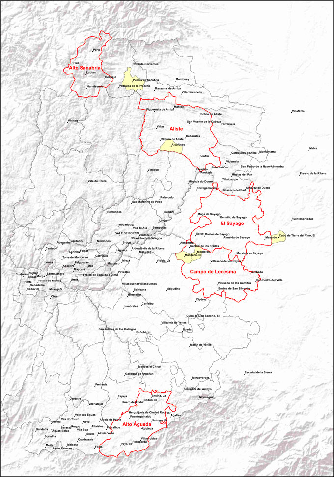
The Map of the territory Duero-Douro is included, with villages and parishes, taking into account this project will be implemented in the Spanish side and occasionally will take place three mentioned actions in Portugal.
| October 2012 | ||||||
| Mon | Tue | Wed | Thu | Fri | Sat | Sun |
|---|---|---|---|---|---|---|
| 1 | 2 | 3 | 4 | 5 | 6 | 7 |
| 8 | 9 | 10 | 11 | 12 | 13 | 14 |
| 15 | 16 | 17 | 18 | 19 | 20 | 21 |
| 22 | 23 | 24 | 25 | 26 | 27 | 28 |
| 29 | 30 | 31 |

© 2012 Territoria.Net. All rights reserved.